On January 10, 2005, the small coastal town of La Conchita experienced a catastrophic landslide. Following a period of torrential rains, the hillside above the community gave way, unleashing a rapid fluid flow of debris and poorly cemented marine sediments. The landslide occurred with devastating speed and force, moving tens of thousands of cubic yards of earth and creating a subsequent debris flow that covered approximately 8 acres.
Aerial photography of the aftermath of this tragic event, from shortly after to a decade later, provides a unique look into what happened on that day and how much continues to be lost due to the landslide.
Where is La Conchita, California?
La Conchita, California is a small town located about 15 miles north of Ventura, on the Southern California coastline. Nestled below the Santa Ynez Mountains, La Conchita lies on a narrow coastal strip overlooking the Pacific Ocean. It has a rich history filled with stories of Spanish Mariners, missionaries, and Native American settlements, with its name coming from the Spanish word la concha, meaning "the shell."
The Impact of the 2005 La Conchita Landslide?
The impact of the disaster on La Conchita was profound. The slide destroyed 13 homes and damaged 23 others, tragically claiming the lives of 10 residents. The narrow strip of land between the Santa Ynez Mountains and the Pacific Ocean was left scarred, with entire neighborhoods buried under slide debris. Emergency services and local authorities responded quickly, but the scale of destruction highlighted the complex nature of the geological hazard in the area.
The 2005 La Conchita landslide underscored the ongoing risk of future landslide activity in the region, prompting county officials to declare the community a Geological Hazard Area. This tragic event served as a stark reminder of the potential dangers posed by seasonal rainfall and the need for effective control measures to prevent future slides. The La Conchita community, along with organizations like the La Conchita Community Organization, a local group dedicated to addressing the ongoing risks of landslides in the area, continues to work towards understanding and mitigating these risks.
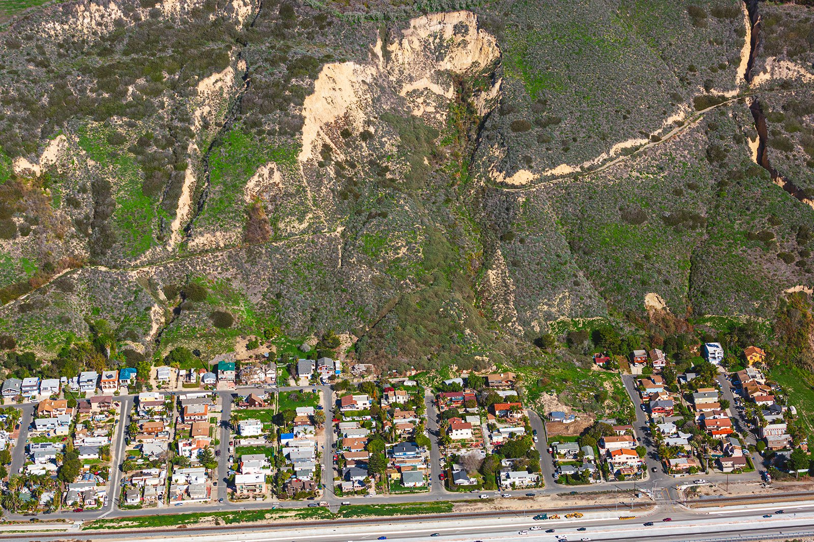
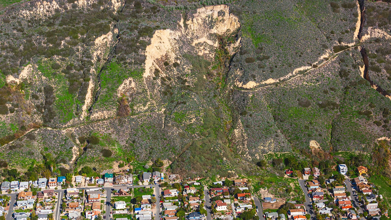
An aerial photograph of the devastating 2005 La Conchita Landslide in Ventura County, California reveals a massive landslide scar that destroyed dozens of homes and businesses, tragically killing 10 people and leaving many more homeless.
Possible Causes of the 2005 La Conchita Landslide
The 2005 La Conchita landslide, which devastated the small coastal town in Ventura County, was primarily triggered by intense and heavy seasonal rainfall. This severe weather event led to a rapid fluid flow of poorly cemented marine sediments, resulting in a massive and destructive slide. However, the complex nature of the landslide suggests multiple contributing factors.
Geologic evidence indicates that landslides have been a recurring issue in the La Conchita area for thousands of years, with modern accounts dating back to 1865. The 1995 La Conchita landslide, which occurred a decade earlier, was a significant precursor to the 2005 disaster. This earlier landslide was largely attributed to agricultural practices, particularly those of the La Conchita Ranch Co. The ranch's cultivation of land on the plateau above the community likely destabilized the hillside, contributing to the hill's failure.
The subsequent debris flow from the 1995 landslide, which moved tens of yards in minutes, buried nine homes, although fortunately, it resulted in no loss of life. Following this event, county officials declared the La Conchita community a Geological Hazard Area due to the ongoing risk of future landslides.
The 2005 landslide, while primarily caused by recent rainfall, was also influenced by the pre-existing instability of the slope, exacerbated by the 1995 event. The combination of natural geological factors and human activities, such as inadequate drainage and agricultural practices, played a significant role in both the 1995 and 2005 landslides.
Understanding these causes is crucial for local authorities and the La Conchita Community Organization as they work to determine control measures and prevent future landslide activity. The devastating impact of the La Conchita landslides underscores the importance of imposing building restrictions and conducting thorough geological surveys to safeguard the community against potential future disasters.
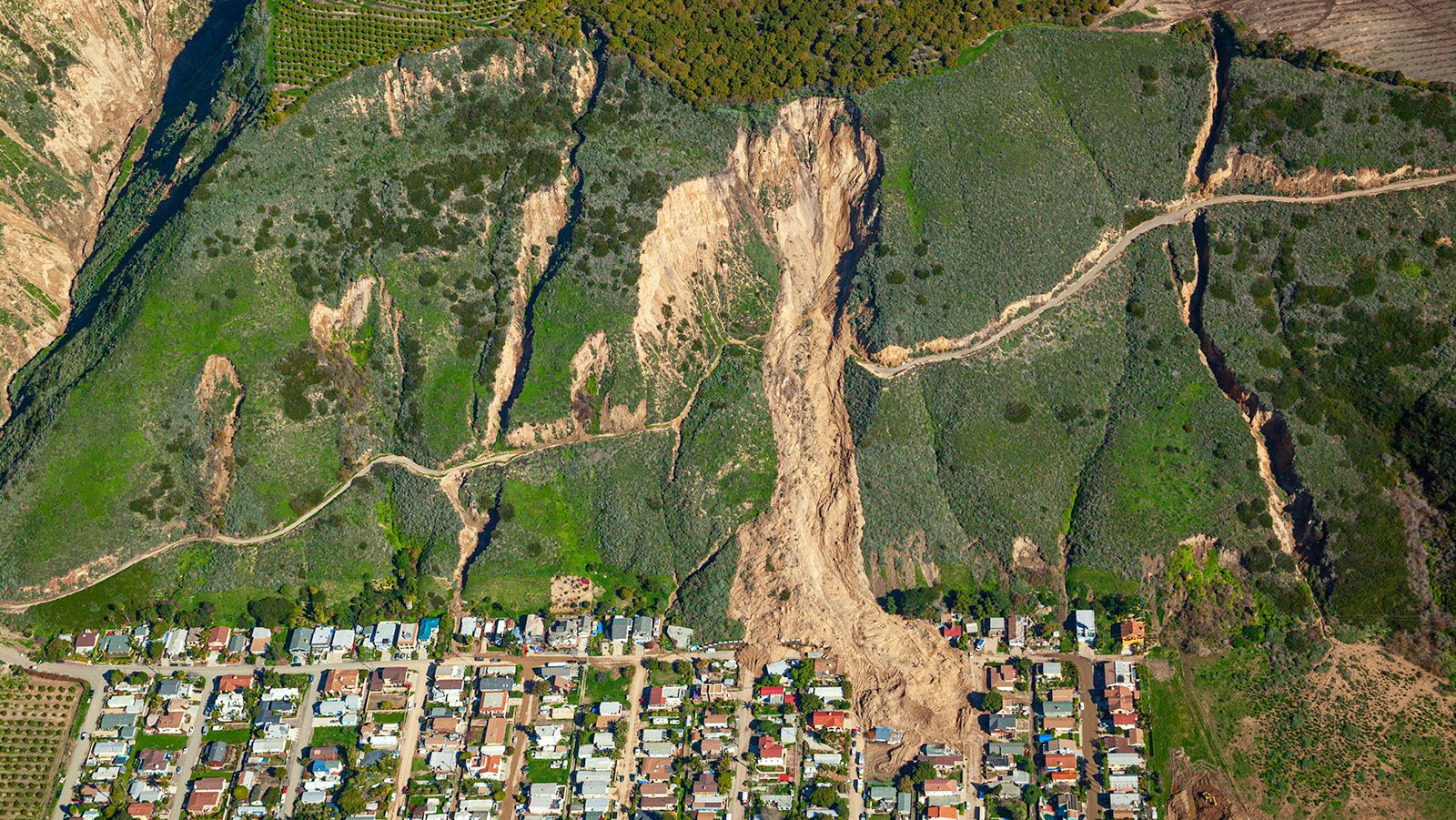
Ten years later, this aerial photograph of La Conchita depicts a massive mudslide that had cascaded down a hill in Ventura County, California and impacted part of the coastal town, burying several homes and tragically claiming 10 lives in its wake.
How Aerial Photography Captured the La Conchita Disaster
Aerial photographs taken of the La Conchita area are some of the most iconic images of the 2005 landslide, as they are able to show the immense scale of the damage— from houses covered by mud and debris to roads blocked off and buried under several feet of mud and rock.
In addition to providing a comprehensive overview of what happened during and after the La Conchita slide, aerial photography also provides invaluable data for researchers studying landslides. By analyzing aerial photos taken before, during, and after natural disasters, scientists can gain valuable insights into how physical landscapes change over time—information that is invaluable in helping to anticipate renewed landslide activity and designing effective mitigation strategies. Analyzing these post-disaster photos, scientists can better understand the various landslide scenarios in the hopes of preventing future landslides.
Documenting Change Over Time From the Air
One of the most powerful aspects of aerial photography is its ability to document change over time. Because aerial photographs are taken from high up in the air, they can provide an incredibly detailed overview—something that would be impossible to do with ground-level photography alone. This makes them particularly useful for capturing events like natural disasters, which tend to be relatively large in scale. In the case of La Conchita, aerial photography allows us to see the full extent of the damage done by the landslide over a long time period, from the massive mounds of dirt blocking roads to entire neighborhoods buried under mud and debris.
The Impact of the 2005 La Conchita Landslide on Residents
Perhaps most importantly, aerial photographs offer us a glimpse into how tragedies like this affect ordinary people. While news stories about natural disasters often focus on numbers and statistics—how many homes were destroyed, how many people were killed and displaced—aerial photographs provide us with a more intimate look at tragedy’s human cost. For example, aerial photos taken after La Conchita’s landslide shows several empty plots where homes used to stand—a stark reminder of the enormous personal impact on the La Conchita community.
The La Conchita Landslide was a devastating event for those who lived there and for Ventura County as a whole. Aerial photography played an important role in documenting one of the area's worst natural disasters in recent history. These images provide us with important insights so that we can better understand the effects of landslides on our communities and are a testament to both the destruction caused by this tragedy and also mankind’s ability to persevere through hard times.