Los Angeles, CA — West Coast Aerial Photography, Inc., a leader in aerial imaging and photogrammetry services, today announced the feature of its Chief Operating Officer, Steven Holtzman, in a new blog post published by Pix4D, a global leader in professional photogrammetry software. The article highlights the successful implementation of Holtzman's innovative concept to deploy high-resolution photogrammetry technology to enhance mosquito abatement and vector control programs.
The featured idea leverages precision imagery, acquired by manned aircraft for large-scale coverage, and innovative Pix4D software solutions to quickly map and identify micro-habitats and standing water bodies -- the primary breeding grounds for mosquitoes.
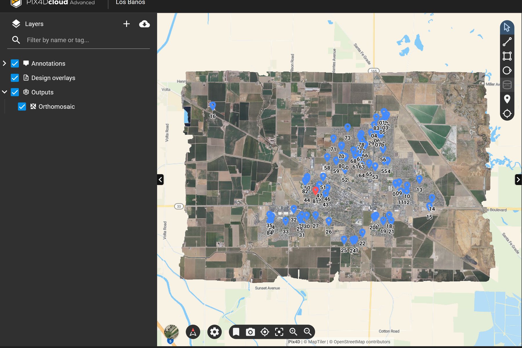
During a recent pilot project in Los Banos, California, West Coast Aerial Photography's advanced workflow delivered striking results, identifying nearly 100 green swimming pools -- many more than were anticipated. Crucially, the data acquisition flight, processing, and delivery of actionable maps was completed in less than 24 hours, a logistical feat initially believed to be impossible.
The need for such a proactive and rapid solution is urgent, as Dengue Fever and West Nile Virus are increasing in California, with mosquitoes acting as the primary vector. Conventional, reactive abatement approaches have been largely unsuccessful in stemming this public health surge.
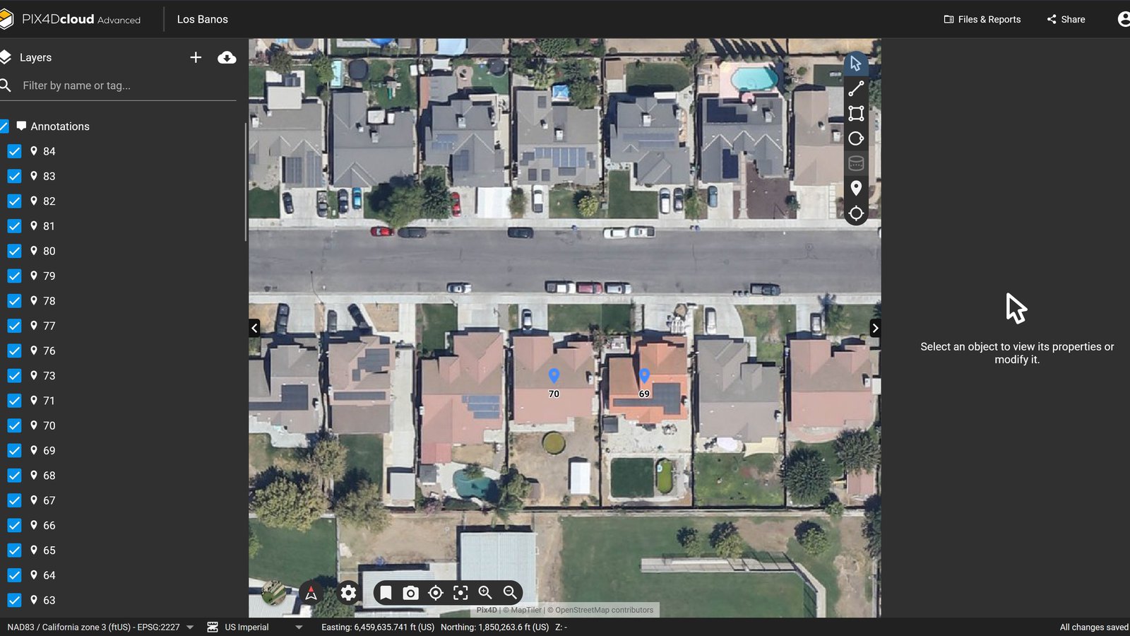
Using Pix4D's cloud platform, the actionable dataset was quickly shared live with mosquito abatement teams, both on the ground and in the office, allowing them to collaborate in real-real time to address the newly discovered mosquito breeding grounds throughout the city.
“When fighting big, persistent problems, sometimes you have to look outside the usual toolbox,” said Steven Holtzman, COO of West Coast Aerial Photography, Inc. “Aerial photogrammetry’s real strength is showing us critical details and context you simply can’t see from the ground. Through this pilot project, we were able to show that using unconventional solutions can solve high-stakes problems in unrelated fields, like using aerial mapping for public health. We’re confident this proactive mapping strategy, alongside the innovative tools developed by Pix4D, will give local mosquito abatement and vector control teams the actionable data they need to proactively reduce mosquito populations throughout the region, and slow the spread of mosquito-borne diseases like Dengue Fever and West Nile Virus. We’re incredibly humbled and grateful to work alongside the dedicated teams who work tirelessly every day to keep our communities safe and healthy.”
Read the full blog post here: https://www.pix4d.com/blog/fighting-disease-mosquito-control-photogrammetry/
About West Coast Aerial Photography Inc.
West Coast Aerial Photography, Inc. is a California-based aerial photography firm specializing in oblique and vertical aerial images. Founded in 2000 by Mark Holtzman, the company is a premier provider of high-resolution aerial photography, and professional photogrammetry services. It specializes in serving sectors that require precise, scalable, and complex aerial data solutions, including construction, environmental engineering, and public works. West Coast Aerial Photography, Inc. is committed to innovation and leveraging cutting-edge technology to help solve complex real-world problems.